Kind : Round trip
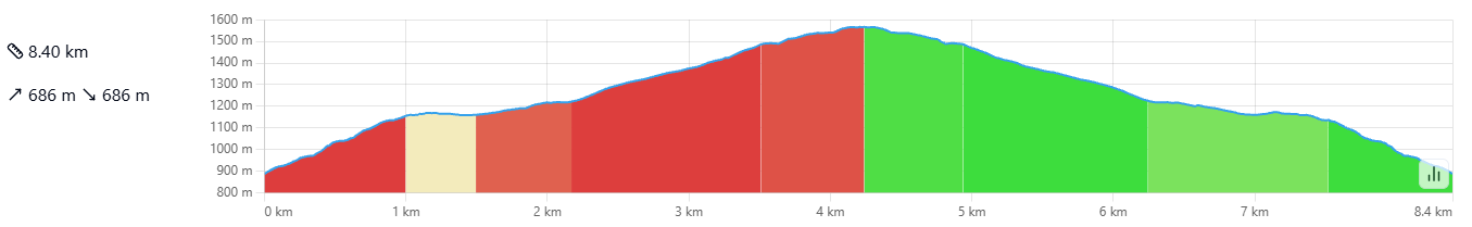
Distance : 8.4 Km
Duration : 5h
Difficulty : Difficult
Pianu Maiò Hiking
The hike described here begins near the village of Santa Lucia di Mercoriu. Another departure is possible from Pian di Vallu but extends the hike somewhat. It is marked in green on the map.
At the start, a sign indicates the Sant'Alesiu chapel on a path marked in orange. We start in the chestnut trees to climb under the chapel by going around the rocky massif to the south. We must remain very vigilant to stay on the main path by following the orange markings. The path climbs sharply with very little flat, it is quite demanding. We arrive under the chapel at 1009 meters above sea level in about an hour. This chapel overlooks the villages of Castellare di Mercoriu, Sermanu, Alandu and Bustanicu.
To climb to the chapel, you have to go around it from the north where the path is less steep. The view is already spectacular on the west with the town of Corti at the bottom of the valley and the two valleys of Restonica and Tavignanu.
We descend to the small Levina Lake. The place is calm, beautiful, and soothing. But you must continue because a big climb awaits you. We notice many vestiges of the rich past of this place: terraces with stone walls, small ruined houses, and aghje. Before you, the imposing massif of Pianu Maiò.
It is impossible to climb it from this side, so you have to go around it from the east. The path heads north – north/east to wind its way into the valley where the Caldane stream flows.
You have to go up the stream to a pass to find yourself under the summit on the eastern side of Pianu Maiò. At the pass the view is superb over the San Petrone and the villages of Rusiu, Carticasi, Cambia, San Lurenzu… It takes 30 to 45 minutes from the lake to the A Prova pass.
From here, the path heads due south, gradually following the massif. You will reach a small pass with a beautiful view of Lake Levina and the Sant'Alesiu chapel.
Then we head due north again on a slightly flatter ridge path. You leave a wooded area on your left to continue to the summit. The summit takes about 2.5 hours from the start. A beautiful wooden cross awaits you with a wonderful view.
Pianu Maiò is known as Monte Piano Maggiore, A Prova or a Zenna Rossa.
The view is magnificent: you can see the entire central chain of the island. We can distinguish the highest peaks: Incudine, Renosu, Monte d'Oru, Monte Rotondu, Paglia Orba, Monte Cintu, Padru and San Petrone with a view of the Boziu pieve and Santa Lucia di Mercoriu.
The return is via the same path in about two hours.
Sources from the website: https://www.corse-randos.com
The San Cervone – Pianu Maiò variant
The start of the hike remains the same as that presented above.
This variant allows you to discover San Cervone and for the more athletic Pianu Maiò also during the same hike.
You have to go up the stream to a pass to find yourself under the summit on the eastern side of Pianu Maiò. At the pass the view is superb over the San Petrone and the villages of Rusiu, Carticasi, Cambia, San Lurenzu… It takes 30 to 45 minutes from the lake to the A Prova pass.
On our right, to the east, we should spot a metal cross: San Cervone. From here we will continue by sight; the path is completely absent and without markings or cairns. We try to stay at the same level, without descending too much into the woods, nor climbing onto the southern ridges.
The return is by the same path. You must return to the pass. Allow 30 minutes for the round trip.
From here, the path heads due south, gradually following the massif. You will reach a small pass with a beautiful view of Lake Levina and the Sant'Alesiu chapel.
Then we head due north again on a slightly flatter ridge path. You leave a wooded area on your left to continue to the summit. The summit takes about 2.5 hours from the start. A beautiful wooden cross awaits you with a wonderful view.
The return is via the same path in about two hours.
Sources from the website: https://www.corse-randos.com
Kind : Round trip
Distance : 9.6 Km
Duration : 5:30 a.m.
Difficulty : Difficult


The North Sea to Sea
From Moriani to Cargèse via Santa Lucia di Mercoriu
The route, consisting of a main trail and a variant, offers a diversity of landscapes and traditions. Indeed, from valley to valley, it stretches at the foot of the highest peaks: Monte Cintu and Paglia Orba.
- From Moriani to Cargèse via Santa Lucia di Mercoriu and Corti
- 8 to 12 days of hiking
- Stages from 4 a.m. to 9 a.m.
- 139km in total (161km for the variant)
Recommended period
The trail and its variant do not present any particular difficulties. Due to passages at 1,500 m, both routes are only suitable from mid-April to November.
The markings
The Mare à Mare and Mare è Monti trails are marked in orange. Trail markings consist of painted marks on trees, rocks, walls, and posts. Their frequency depends on the terrain.
You can discover the Mare à Mare through short stages that will allow you to discover the entire Boziu region.